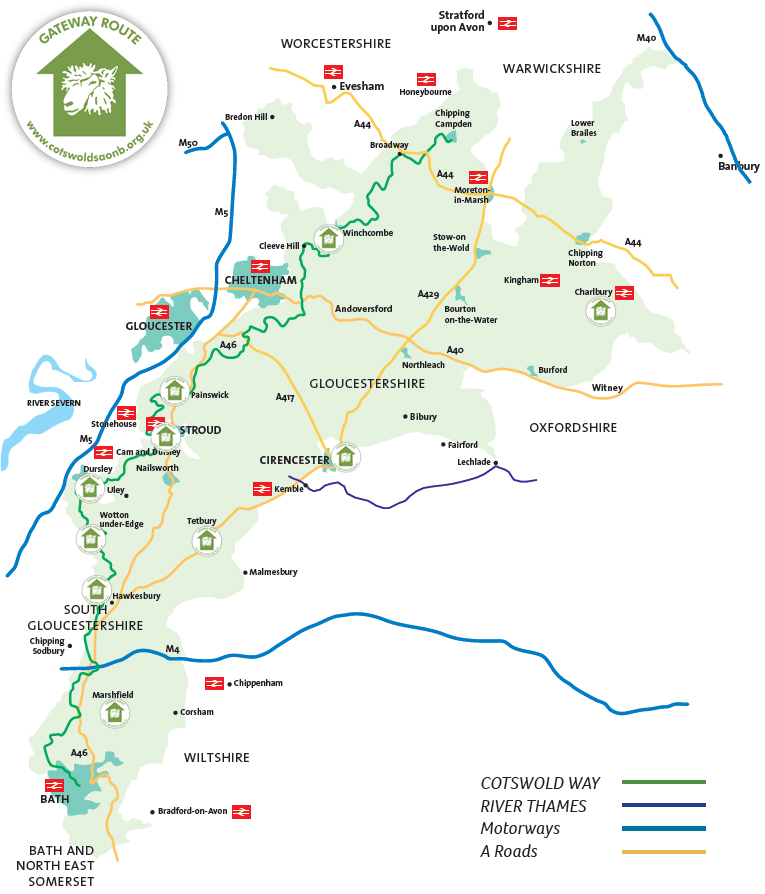
 Cotswolds National Landscape has worked with local communities to create ten Cotswold Gateways locations, from which people can follow walking and cycling routes to explore the surrounding countryside of the Cotswolds Area of Outstanding Natural Beauty.
Following footpaths, bridleways, and minor roads, these routes provide opportunities to discover hidden corners, epic views, historic sites, and a rich diversity of wildlife.
Waks are available to download as PDF or GPX files, cycle routes are able to be downloaded as GPX files or viewed online through Outdoor Active.
If you are using public transport to get to and from your walk, please check routes and timetables online before travelling.
Charlbury
Nestling in the Evenlode Valley with its own railway station, Charlbury is a vibrant yet picturesque Oxfordshire town. A centre for festivals, full of welcoming pubs, and ideal for walking and cycling, there’s always something going on in Charlbury. Charlbury is accessible via train from Oxford, Reading, London Paddington, Worcester and Great Malvern; by bus from Oxford, Witney and Chipping Norton; with carparking at Charlbury Station.
 Walk 1 – Circular via Mill Field (1.8 miles, 45 mins, easy) [gpx]
An easy walk following the River Evenlode, with views across the Evenlode Valley to Cornbury Park and Wychwood Forest.
![]() Walk 2 – Circular via Banbury Hill (2.2 miles, 1 hour, easy) [gpx]
Walk 2 – Circular via Banbury Hill (2.2 miles, 1 hour, easy) [gpx]
Another easy walk through some wooded areas, up Banbury Hill, with fine views across the surrounding Cotswolds countryside to the Evenlode Valley and Wychwood Forest, and then onto Wigwell Nature Reserve (7Ha of unimproved limestone grassland – in summer months, its steeply sloping meadows become a riot of colourful wildflowers).
Cirencester
This vibrant historic Roman town of Cirencester has lots of places to visit, eat and drink. The nearest railway station is at Kemble (around 7 miles, so taxi or bus required) providing access from Stroud, Gloucester, Cheltenham, Swindon, London Paddington, Reading, Bath, and Bristol. National Express and Megabus run services from London, and there is a local Stagecoach bus route from Cheltenham; Carparks in Cirencester include Abbey Grounds car park, Brewery car park, Old Station car park, Waterloo car park, Forum car park (all car parks are pay and display).
![]() Cirencester’s Heritage & Green Spaces Walking and Cycling Route (3.47 miles, 3 hours, easy) [gpx]
Cirencester’s Heritage & Green Spaces Walking and Cycling Route (3.47 miles, 3 hours, easy) [gpx]
An easy walk and cycle route taking in the Abbey Grounds lank and the C12th Norman Arch; past earthwork remains of the Roman Wall of Corinium; City Bank Nature Reserve; Cirencester Roman Amphitheatre and Querns Wood; across Four Acre Field; past the Corinium Museum (well worth a visit) finishing in Market Place and the Parish Church.
Dursley
Dursley is an old market town in the heart of the Cotswold hills, with its 18th-century market hall, raised on pillars like stilts. Dursley was once a hub of the cloth-making industry that supported so many Cotswold villages and there are many older houses that stand as a testament to Dursley’s former prosperity. Dursley is accessible via bus from Stroud, Gloucester, Cheltenham, rail and bus from Bath, with long stay carparks in May Lane and Long Street. There are plenty of places to eat and drink in Dursley
![]() Walk 1 – Figure of Eight: Eastern Loop (8 miles, 4.5 hours, moderate) [gpx]
Walk 1 – Figure of Eight: Eastern Loop (8 miles, 4.5 hours, moderate) [gpx]
This walk takes a route around the Uley Valley taking in the fields and woods on the south side leading to Owlpen Manor, and then returns on the north side going over Uley Bury and Cam Peak, two great viewpoints. There are three good climbs and some stony paths and steep descents that makes this half of the Figure 8 quite challenging. If you are feeling fit and have the time, there is also the option to visit a further viewpoint on Downham Hill after descending from Uley Bury (this adds an extra half mile to your walk).
![]() Walk 2 – Figure of Eight: Western Loop (8 miles, 4.5 hours, moderate) [gpx]
Walk 2 – Figure of Eight: Western Loop (8 miles, 4.5 hours, moderate) [gpx]
This walk takes a wide loop, west, around the town of Dursley through fields, woods, and Stinchcombe Hill golf course and offers panoramic views from the Cotswold Way above steep slopes in all directions and supporting a wide biodiversity of flora and wildlife. There is a sustained climb early on and one descent which can be muddy and uneven, otherwise paths are good.
Hawkesbury Upton
A picturesque village in South Gloucestershire, along the Cotswold Way. The Somerset Monument on the Cotswold Edge nearby, was designed by Lewis Vulliamy, and was constructed in 1846 as a memorial to Lord Edward Somerset who led the British cavalry at the Battle of Waterloo. Hawkesbury upton is accessible by 84 & 85 buses from Wotton-under-Edge and Yate; the Village Hall Carpark can be used if the Hall is not in use so please check the Hall calendar to confirm. Refreshments are available at the Beaufort Arms, Fox Inn and Hawkesbury Stores.
![]() Walk 1 – Circular via Kilcott (4 miles, 1.5-2 hours, moderate) [gpx]
Walk 1 – Circular via Kilcott (4 miles, 1.5-2 hours, moderate) [gpx]
This walk passes through fields and woods, with views of Newark Park , Wotton-under-Edge below the Cotswold Escarpment, and will take you past the Hawkesbury (Somerset) monument.
![]() Walk 2 – Circular via Hawkesbury Church (3.75 miles, 1.5-2 hours, moderate) [gpx]
Walk 2 – Circular via Hawkesbury Church (3.75 miles, 1.5-2 hours, moderate) [gpx]
The highlight of this walk is the Church of St Mary the Virgin, set in a beautiful, peaceful location below the historic and steep sided Hawkesbury Knoll, and splendid views at the top of the Knoll west over the Vale of Berkeley, and the River Severn to the Forest of Dean and Wales.
Marshfield
The small market town of Marshfield is rich in history built up around its strategic location in the heart of Cotswold wool country, near to Bath and Bristol. The eastern part of the village contains the parish church, Manor House and Home Farm, an important group of historic buildings noted for their architectural features. Marshfield is accessible by bus from Chippenham, Bath, Colerne and Bristol. There is parking at Withymead Recreation Ground, SN14 8PB. Refreshments are available at The Catherine Wheel and Sweet Apples Tea Shop.
![]() Walk 1 – Cloud Wood Loop (3 miles, 1.5-2 hours, moderate) [gpx]
Walk 1 – Cloud Wood Loop (3 miles, 1.5-2 hours, moderate) [gpx]
A circular walk through Cloud Wood with wonderful countryside views from the top of the slope.
![]() Walk 2 – Southern Loop Hill (4.5 miles, 2.5 hours, moderate) [gpx]
Walk 2 – Southern Loop Hill (4.5 miles, 2.5 hours, moderate) [gpx]
Enjoy initial views across to Cold Ashton, St. Catherine’s Valley and Charmy Down, then take in wonderful views of Claverton Down (University of Bath), Limpley Stoke Valley and the distant Mendip Hills.
![]() Walk 3 – Circular walk to St Catherine’s Valley (7.5 miles, 4-4.5 hours, moderate) [gpx]
Walk 3 – Circular walk to St Catherine’s Valley (7.5 miles, 4-4.5 hours, moderate) [gpx]
St Catherines Valley is a 156.1 hectare biological Site of Special Scientific Interest. The valley has lots of wild flowers at the appropriate time of year as well as a good selection of wildlife. The walk joins the Limestone Link, and above Cherry Wood you can stop and enjoy the view across the valley towards Claverton Down.
![]() Walk 4 – Cold Ashton, Doynton, Dyrham & West Littleton (11 miles, 5-5.5 hours, strenuous) [gpx]
Walk 4 – Cold Ashton, Doynton, Dyrham & West Littleton (11 miles, 5-5.5 hours, strenuous) [gpx]
This walk offers lovely views including the River Severn with both its bridges, and passes through Dyrham Park woodland. There is opportunity for food and refreshments at the half way stage at the Cross House public house in Doynton.
Painswick
The historic wool town of Painswick, known as ‘The Queen of the Cotswolds’, is one of the finest and best-preserved Cotswold settlements, nestling quietly in the hills and surrounded by some of the Cotswolds’ most delightful countryside. Painswick is at the mid-point of the Cotswold Way and surrounded by marvellous walking country. The world famous Rococo Gardens, Painswick Beacon, church of St. Mary (sitting amongst 99 yew trees) are all within easy access. Award winning hotels and inns and some specialist craft and antique shops are all situated in the centre of the village.
![]() Walk 1 – Circular walk along the Painswick Stream (3 miles, 1-1.5 hours, moderate) [gpx]
Walk 1 – Circular walk along the Painswick Stream (3 miles, 1-1.5 hours, moderate) [gpx]
A lovely walk along Painswick Stream with a short detour to the millpond at Painswick Mill.
![]() Walk 2 – Circular walk upto Frith Wood (4 miles, 2 hours, strenuous) [gpx]
Walk 2 – Circular walk upto Frith Wood (4 miles, 2 hours, strenuous) [gpx]
The walk takes you to Frith Wood Nature Reserve, a wonderful 24Ha ancient beech wood that straddles the ridge overlooking Painswick Valley and Slad Valley near Stroud. Spring sees the woodland floor carpeted in bluebells and wild garlic. There is a 1.5 mile detour for those wishing to visit Slad, the setting for Cider with Rosie, and places associated with Laurie Lee, including the Woolpack Inn (Laurie’s favourite pub).
Stroud
Stroud thrived on its woollen mills in the Industrial Revolution, some of which now open to visitors to enjoy guided tours. In Stroud, you will find an eclectic mix of galleries, cafes and shops – selling everything from fossils to fairies and vintage to vinyl – and one of the best Farmers’ Markets in the country. Set against the beautiful backdrop of the Five Valleys, the town is easily reachable by train, bus or car.
![]() Walk 1 – Circular via Capel’s Mill and Rodborough Common (3 miles, 1.5 hours, strenuous) [gpx]
Walk 1 – Circular via Capel’s Mill and Rodborough Common (3 miles, 1.5 hours, strenuous) [gpx]
This walk takes you through Frome Banks Nature Reserve, or you can walk along the canal tow path instead; then up and across Rodborough Common where you can wander at your own pace through a sea of yellow cowslips (in March/April) or a swathe of early purple orchids (in April/May) and marvel at the breathtaking views over the Stroud valley and Severn estuary; then descend to follow the Stroud Waterway tow path back into Stroud.
![]() Walk 2 – Circular via Canal and Stratford Park (1.2miles, 0.5 hours, moderate) [gpx]
Walk 2 – Circular via Canal and Stratford Park (1.2miles, 0.5 hours, moderate) [gpx]
This walk takes you along the Stroud Water canal tow path to Stratford Park (56 acres with leisure centre, museum, arboretum, woodland, lake, formal gardens and play areas).
Tetbury
Tetbury is the second largest town in the Cotswolds. It is the home of HRH Prince Charles, the Prince of Wales, and the Duchess of Cornwall and, was an important market for Cotswold wool and yarn during the Middle Ages. Today, it is better associated with boutique shops, great food, and its Royal Connections. The nearest railway station is at Kemble (around 8 miles, so bus or taxi required) providing access from Stroud, Gloucester, Cheltenham, Swindon, London Paddington, Reading, Bath, and Bristol The No 69 bus operated by Stagecoach and 129 bus operated by Cotswold Green both run from Stroud, the 882 by Stagecoach from Gloucester, Cirencester, and Kemble. There are four carparks in Tetbury including at Tetbury Goods Shed where the walk starts.
![]() Walk – Circular via Ashley (6.5 miles, 3 hours, moderate) [gpx]
Walk – Circular via Ashley (6.5 miles, 3 hours, moderate) [gpx]
The walks starts by following the old railway line, then heads across fields to the village of Ashley with its duck pond and small C12 St James church, joining the Monarchs Way walking through the wonderful countryside back to Tetbury.
Winchcombe
Winchcombe is a Cotswold town with timbered inns, quality shops, centuries-old architecture and stunning countryside offering beautiful walks, and a castle! Parking is available in Back Lane Carpark GL54 5PZ for £1 a day. Train services are available from Cheltenham Spa, 9 miles and Evesham, 11 miles. National Express coaches run from Cheltenham and Stagecoach and Pulhams run frequent bus services daily, between Winchcombe and Cheltenham.
![]() Walk 1 – Winchcombe to Sudeley Castle (2 miles, 1 hour, easy) [gpx]
Walk 1 – Winchcombe to Sudeley Castle (2 miles, 1 hour, easy) [gpx]
An easy walk with views across the valley to Winchcombe, that takes you across the River Isbourne, through the grounds of Sudley Castle (where Katherine Parr, the sixth wife of Henry VIII, is buried) and past the castellated Almondsbury Lodge.
![]() Walk 2 – Winchcombe to Langley Hill Wood Carving (4.5 miles, 2-2.5 hours, moderate) [gpx]
Walk 2 – Winchcombe to Langley Hill Wood Carving (4.5 miles, 2-2.5 hours, moderate) [gpx]
This walk to the Langley Hill Wood Carving (a shepherd and his dog) takes you across beautiful countryside offering views of Winchcombe, the Vale of Evesham and Cleeve Hill.
![]() Walk 3 – Sudeley, Kenelm and Monk’s Hole (4.75 miles, 2.75 hours, strenuous) [gpx]
Walk 3 – Sudeley, Kenelm and Monk’s Hole (4.75 miles, 2.75 hours, strenuous) [gpx]
A scenic walk that takes you across the River Isbourne, through the grounds of Sudeley Castle, past the castellated Almondsbury Lodge and onto St Kenelm’s Well. The walk then joins the Winchcombe Way, if you are lucky you may see Stanway Fountain, then onto the Gloucester Way with views looking towards Toddington, the Malverns and Winchcombe railway station.
![]() Walk 4 – Winchcombe to the source of the River Isbourne (6 miles, 3 hours, moderate) [gpx]
Walk 4 – Winchcombe to the source of the River Isbourne (6 miles, 3 hours, moderate) [gpx]
This walk follows the River Isbourne from its source some 200m upstream from The Washpool (a deep, keyhole-shaped trough with stone sides used at one time as a sheep dip, fed by the pond immediately above it) all the way into Winchcombe.
![]() Walk 5 – Winchcombe to Belas Knap Long Barrow (5.5 miles, 2-2.75 hours, moderate) [gpx]
Walk 5 – Winchcombe to Belas Knap Long Barrow (5.5 miles, 2-2.75 hours, moderate) [gpx]
A popular walk with views over the Isbourne valley to the hills north-west of Winchcombe as you walk to Belas Knap
(a particularly fine example of a Neolithic long barrow, with a false entrance and side chambers), then further views as you return to Winchcombe of Sudley Castle and St Mary’s Church.
![]() Walk 6 – Farmcote to Hailes Abbey (7.5 miles, 4 hours, moderate) [gpx]
Walk 6 – Farmcote to Hailes Abbey (7.5 miles, 4 hours, moderate) [gpx]
This walk to the ruins of Hailes Abbey, provides lovely views of Winchcombe and Sudeley valley, Hayles Fruit farm and beyond to Evesham, Farmcote valley and the Malvern Hills.
Cycle routes are currently only available to download as GPS Exchange Format files, but can also be viewed online via Outdoor Active using the “View route” links below.
![]() Cycle 1 – Cleeve Cloud (12.5 miles, 435m ascent) [View route]
Cycle 1 – Cleeve Cloud (12.5 miles, 435m ascent) [View route]
Circular route from Winchcombe via Cleeve Hill, Nottingham Hill and Prescott.
Refreshments available in Winchcombe and at the Cotswold Way Cafe on Cleeve Hill.
![]() Cycle 2 – Guiting Loop (15.5 miles, 512m ascent) [View route]
Cycle 2 – Guiting Loop (15.5 miles, 512m ascent) [View route]
Circular route from Winchcombe via Sudeley and Guiting Power.
Refreshments available in Winchcombe and at the Old Post Office, Hollow Bottom or Farmers Arms in Guiting Power.
![]() Cycle 3 – West Wood (18 miles, 547m ascent) [View route]
Cycle 3 – West Wood (18 miles, 547m ascent) [View route]
Circular route from Winchcombe via Sudley, Charlton Abbots, Sevenhampton and Hawling.
Refreshments available in Winchcombe.
![]() Cycle 4 – Dirtybridge and back (20.5 miles, 560m ascent) [View route]
Cycle 4 – Dirtybridge and back (20.5 miles, 560m ascent) [View route]
Circular route from Winchcombe past Hailes Abbey ruins, Snowshill, Stanton, Stanway and Didbrook.
Refreshments available in Winchcombe, Snows Hill Arms, Snowshill Cafe (National Trust) The Mount Inn, Stanton Village Club, the Coffee Pot Cafe (a small detour from Stanway to Toddington Steam Railway Station).
Wotton-under-Edge
A vibrant town on the Cotswold Way, Wotton boasts a great range of independent shops, host of historic attractions and many excellent amenities.
![]() Walk 1 – Tyley Bottom, Ozleworth and Newark (7.5 miles, 4 hours, difficult) [6 miles gpx] [7.5 miles gpx]
Walk 1 – Tyley Bottom, Ozleworth and Newark (7.5 miles, 4 hours, difficult) [6 miles gpx] [7.5 miles gpx]
This walk initially follows Combe stream, joining the Cotswold Way, before taking you through Tyley Bottom, an empty, isolated valley of great scenic beauty, then follows another stream across Cotswold countryside, then uphill towards Ozleworth radio/TV beacon on past Ozleworth Manor and Newark Park. A shorter route is available. [Taster video]
![]() Walk 2 – Brackenbury Ditches & Tyndale Monument (4.9 miles, 4 hours, moderate) [gpx]
Walk 2 – Brackenbury Ditches & Tyndale Monument (4.9 miles, 4 hours, moderate) [gpx]
Follow the Cotswold Way to Wotton Hill with its magnificent views across the Severn Vale, then along Westridge Woods to Brackenbury Ditches (a 2000 year old hill fort), and onto Tyndale Monument. The monument is open 24 hours a day, and the reward for climbing the 120 steps is a wonderful view of the Berkeley Vale and the river Severn to the Black Mountains. The monument is open 24 hours a day every day. [Taster video]
![]() Walk 3 – Wortley, Tor Hill, Coombe Hill and Wotton Hill (6.2 miles, 3-4 hours, moderate) [gpx]
Walk 3 – Wortley, Tor Hill, Coombe Hill and Wotton Hill (6.2 miles, 3-4 hours, moderate) [gpx]
A wonderful countryside and woodland walk, including sunken lanes and scenic hilltop views out across the Severn Vale and beyond. [Taster video]
![]() Walk 4 – Holywell Leaze and Coombe (2.5 miles, 4 hours, easy) [gpx]
Walk 4 – Holywell Leaze and Coombe (2.5 miles, 4 hours, easy) [gpx]
This trail follows the Marceshi Walk along a stream, then the Cotswold Way to Holywell Leaze and a further streamside path to Coombe Lakes and the quiet hamlet of Coombe. A path around the top of Combe Hill offers magnificent views across Wotton and the Severn Vale.
Thank you to Dale Curtis for allowing us to share his drone videos which really do show the beauty of the area.
Cycle routes are currently only available as GPS Exchange Format files which can be downloaded for use with GPX viewer apps:
![]() Cycle 1 – Circular via Tyley Bottom, Ozleworth and Newark Park (9 miles longer route, 443m ascent) [View route]
Cycle 1 – Circular via Tyley Bottom, Ozleworth and Newark Park (9 miles longer route, 443m ascent) [View route]
Circular route Wotton-under-Edge via North Nibley and beyond, including off-road. It is worth a detour into Breakheart Quarry, where there is a cycle track around the estate (very challenging). Refreshments available in North Nibley, Wotton-under-Edge and also and the New Inn, Waterly Bottom.
![]() Cycle 1 – Circular via North Nibley (7 miles shorter route, 302m ascent) [View route]
Cycle 1 – Circular via North Nibley (7 miles shorter route, 302m ascent) [View route]
Circular route Wotton-under-Edge via North Nibley, including off-road . It is worth a detour into Breakheart Quarry, where there is a cycle track around the estate (very challenging). Refreshments available in North Nibley, Wotton-under-Edge and also and the New Inn, Waterly Bottom.
![]() Cycle 2 – Circular via Bradley Green, North Nibley and Stinchcombe (11 miles, 364m ascent) [View route]
Cycle 2 – Circular via Bradley Green, North Nibley and Stinchcombe (11 miles, 364m ascent) [View route]
This 11 Mile all on-road ride starts Wotton-under-Edge, and visits Bradley Green, North Nibley and Stinchcombe, some stretches on the busy B4060. Refreshments available in Wotton-under-Edge, also The Black Horse Inn and T&Cakes North Nibley
![]() Cycle 3 – Circular via Ozleworth, Alderley, Kilcott, Tresham and Hillesley (14 miles, 512m ascent) [View route]
Cycle 3 – Circular via Ozleworth, Alderley, Kilcott, Tresham and Hillesley (14 miles, 512m ascent) [View route]
Circular route from Wotton-under-Edge via Wortley, Alderley, Tresham and Ozleworth. Includes off-road. Some great climbs, descents and views here. Descent through Frith Wood/Claypit Wood challenging when wet. Refreshments available in Wotton-under-Edge and The Fleece Inn Hillesley.
![]() Cycle 3 – Circular via Ozleworth, Alderley, Kilcott and Tresham (10 miles, 415m ascent) [View route]
Cycle 3 – Circular via Ozleworth, Alderley, Kilcott and Tresham (10 miles, 415m ascent) [View route]
Circular route from Wotton-under-Edge via Wortley, Alderley, Tresham and Ozleworth. Includes off-road. Some great climbs, descents and views here. Refreshments available in Wotton-under-Edge.
![]() Cycle 4 – Circular via Wortley, Newark Park and Tor Hill (7 miles longer route, 262m ascent) [View route]
Cycle 4 – Circular via Wortley, Newark Park and Tor Hill (7 miles longer route, 262m ascent) [View route]
Circular route from Wotton-under-Edge via Wortley, Hillmill Lane, Newark Park (ascent), Tor Hill (descent), including off-road. Refreshments available in Wotton-under-Edge.
![]() Cycle 4 – Circular via Blackquarries Hill and Tor Hill (4 miles shorter route, 189m ascent ) [View route]
Cycle 4 – Circular via Blackquarries Hill and Tor Hill (4 miles shorter route, 189m ascent ) [View route]
Circular route from Wotton-under-Edge with a climb up Blackquarries Hill on road and descent on the off-road section of Tor Hill, returning to Wotton. Refreshments available in Wotton-under-Edge.
.
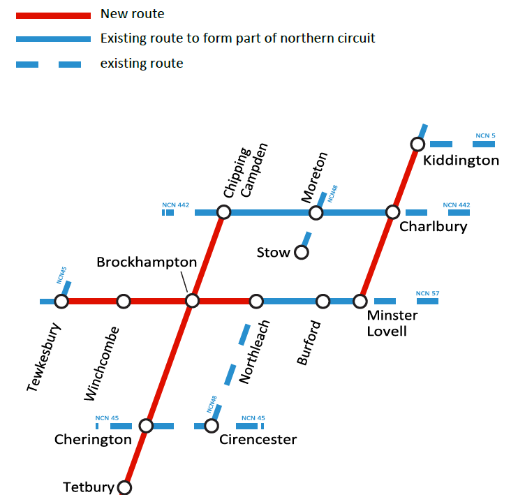
Cotswold Cycleway
These cycle routes are currently only available as GPS Format files which can be downloaded for use with GPX viewer apps.
Cotswold Gateways also includes the Cotswold Cycleway, providing three new signposted routes between
![]() Chipping Campden to Tetbury (40.36 miles, 794m ascent) [View route]
Chipping Campden to Tetbury (40.36 miles, 794m ascent) [View route]
Linear signposted scenic route from Chipping Campden via Broadway Tower, Snowshill, Brockhampton, Severnhampton, Andoversford, Withington, Colesbourne, Winstone and Cherington to Tetbury.
![]() Kiddington to Minster Lovell (13.65 miles, 290m ascent) [View route]
Kiddington to Minster Lovell (13.65 miles, 290m ascent) [View route]
Linear signposted route from the village of Kiddington near Woodstock via Charlbury and Leafield to the picturesque village of Minster Lovell. Reputedly the region’s most haunted village, Minster Lovell is perhaps best known the ruins of its 15th century hall.
![]() Tewkesbury to Northleach (24.11 miles, 367m ascent)
Tewkesbury to Northleach (24.11 miles, 367m ascent)
helping provide the following longer cycle routes
![]() Tewkesbury to Kiddington (54.46 miles, 883m ascent )
Tewkesbury to Kiddington (54.46 miles, 883m ascent )
![]() Cotswold Loop (72.91 miles, 1185m ascent)
Cotswold Loop (72.91 miles, 1185m ascent)
If any of the directions on the walks or cycle routes need updating, please do let us know by emailing: info@cotswolds-nl.org.uk